Prof. ir.
Wim van den Bergh Architect
Prof. ir.
Wim van den Bergh Architect

“Contemplations for Copenhagen”
Copenhagen Cultural Capital of Europe 1996
The Cartography of the Pause, Visions for Copenhagen
Publication: 1995/02, 1996/02, 2002/04
Exhibition: Charlottenborg Udstillingsbygning, 28.12.1995 / 04.02.1996

1995/02
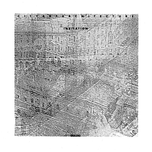
Selected Invitations
Invitations
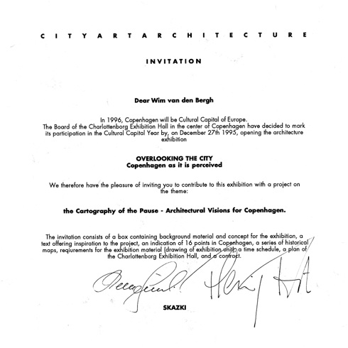
The Cartography of the Pause
By Cityarchitektur: Eric Andersen,
Helle Juul & Flemming Frost
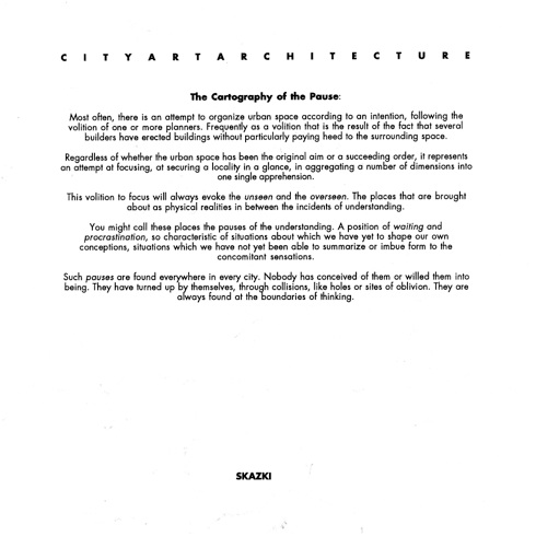
Most often there is an attempt to organize urban space according to an intention, following the volition of one or more planners. Frequently as a volition that is the result of the fact that several builders have erected buildings without particularly paying heed to the surrounding space. Regardless of whether the urban space has been the original aim or a succeeding order, it represents an attempt at focusing, at securing a locality in a glance, in aggregating a number of dimensions into one single apprehension. This volition to focus will always evoke the unseen and the overseen. The places that are brought about as physical realities in between the incidents of understanding. You might call these places the pauses of the understanding. A position of waiting and procrastination, so characteristic of situations about which we have yet to shape our own conceptions, situations which we have not yet been able to summarize or imbue form to the concomitant sensations.
Such pauses are found everywhere in every city. Nobody has conceived them or willed them into being. They have turned up by themselves, through collisions, like holes or sites of oblivion. They are always found at the boundaries of thinking. The Cartography of the Pause evolves as an alternative way of reading Copenhagen's overlooked sites. The Cartography of the Pause deals with the obscure transitions and pauses in between places in the city which are culturally and socially saturated with meaning. But these pauses in the urban space are only seemingly empty. If one focuses in on them, they reveal unexpected secrets and thus provide a completely different way of interpreting the concepts of site and space.
The Cartography of the Pause is a cultural city project, which except from the basic elaborated material will comprise contributions from Danish and international architects. The project continues throughout 96.
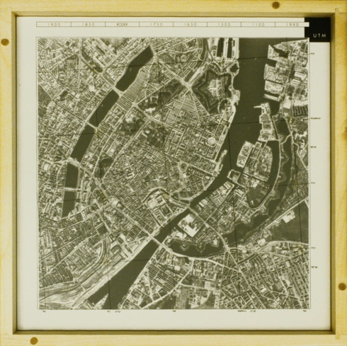
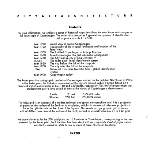
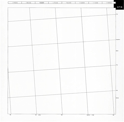
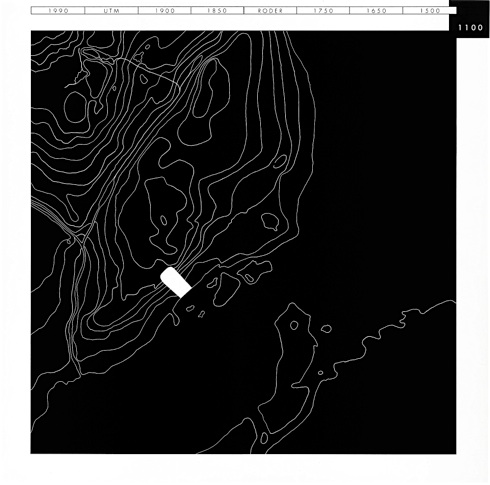
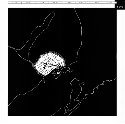
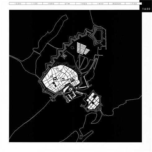
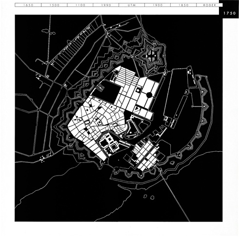
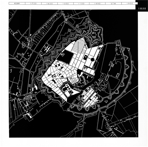
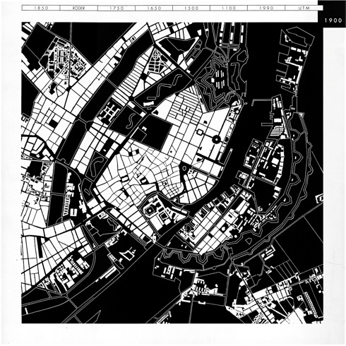
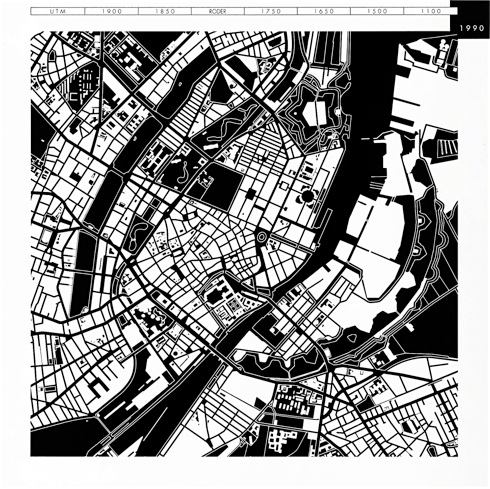
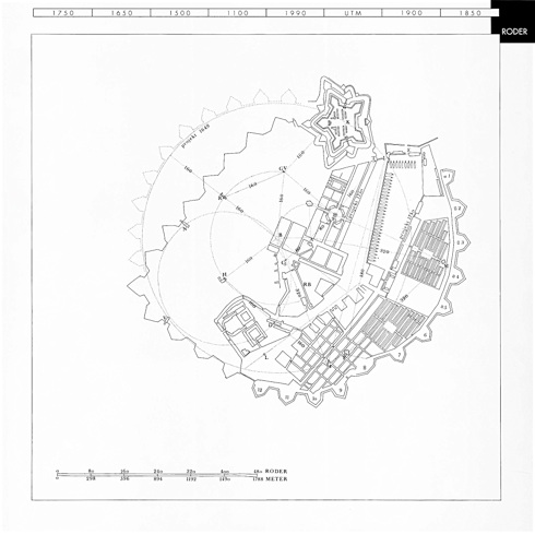
In the light of a series of historical maps we compare 2 geometrical systems of identification: The Copenhagen Roderplan - a local identification system with the Universal Transverse Mercator Grid - a global identification system.
The Roder plan is a cartographic a-nalysis of Copenhagen, carried out by architect Nis Nissen in 1989. In the Roder plan, the historical monuments of the city are located. The UTM grid on the contrary is an example of a modern technical and global cartographical tool. Where the Roderplan locates places of meaning the UTM net locates arbitrary places in the city-context.
We have chosen to let the UTM grid point out 16 locations in Copenhagen, corresponding to the area covered by the Roder plan. Each location has been dealt with on a separate sheet of paper - each architect is asked to relate to one or more of these 16 chosen locations.
The Cartography of the Pause deals with this displacement of meaning.


Contemplations for Copenhagen
Wim van den Bergh
Cities, when perceived and experienced as spatio-material artifacts that developed over time, often appear to us as accumulations of ‘effects’. Effects’ of which the ‘causes’ are mostly imperceivable.
‘Causes’ that even for its citizens are often unknown or lost. Streets have directions but what caused their direction? Urban blocks have a shape but what caused their shape? Buildings have heights but what caused their height? There are colors, materials, textures but what caused their choice? Were it geomorphological circumstances, factors of ground ownership, political decisions, urbanistic solutions, technical possibilities or economical reasons that caused the spatio-material elements of the city to be as they are?
Asking such questions to oneself as an architect one becomes aware of the fact that the perceptible appearance of a city like Copenhagen cannot be explained satisfactorily as just being the spatio-material expression of urbanistic ‘causality’ as such.
In its perception a city as a built artifact does not explain itself by simply being the historical accumulation of rational solutions to the material problems of dwelling (i.e. technique, production, marketing, circulation, hygiene etc.), in its appearance and perception the city of Copenhagen first and for all, like other cities, seems to enshrine the immaterial hopes and fears of its citizens. Thinking about perceiving and apprehending a city one then realizes that the appearance of a city in relation to its perception and apprehension develops the other way around, so by means of a sort of ‘reversed causality’. A ‘reversed causality’ in which, from an individual’s point of view, the existing and perceived ‘effects’ are read and become the ‘cause’ for an imagination, the imagination of new ‘effects’, a new appearance like in Calvino’s “invisible Cities”. Or, from a more collective point of view, the existing ‘effects’ are first read and then in reverse overlaid with the unifying concept of a plausible ‘cause’, which then becomes the ‘cause’ for the new ‘effect’, a concept for the cities future appearance. This one could say is like a reinterpretation of an existing situation to -using the words in the project's brief- “aggregate a number of dimensions into one single apprehension” thus -like an Augur in antiquity would do in the rite of inauguration- “evoking the ‘unseen’ and the ‘overseen’”. Reading the brief and looking at the intriguing material I received to participate in “The Cartography of the Pause. Architectural Visions for Copenhagen” I couldn’t escape the idea that what was asked from the participating architects was actually to act as Augurs and to inaugurate the sixteen locations they were given.
Sixteen locations that are very specific in the way that they are crossing points in the Universal Transverse Mercator Grid of the global identification system and at the same moment are non-locations in the way that the urban fabric of Copenhagen and its citizens don’t recognize them as such. In other words they are not recognized as being specific locations, they don’t have an identity (yet). But to be recognized and gain an urban identity these locations would have to be inaugurated, they would have to be ceremoniously installed and inscribed into the urban fabric of Copenhagen by its citizens. An inauguration in which the roll of the invited architects and artists would be that of an Augur, the reader and interpreter of the signs that appear within the ‘templum’ of each of the locations.
In ancient times an ‘inauguratio’ lay at the basis of every organization of space.
The transformation of non-locations into specific and universal locations, like the founding of a new city, happened by means of a complex rite called ‘Contemplatio’, which consisted of a naming of signs, a description of the Augur’s field of vision, the ‘templum’, and a reading and determination of the significance of the signs.
The specific terms for the culminating acts of this ‘Contemplatio’, according to Joseph Rykwert in his book “The Idea of a Town”, were ‘conregio’ , ‘conspicio’ and ‘cortumio’.
And this is how the Augur in ancient times carried out his duties:
1. ‘Conregio’*: For the ‘conregio’ the Augur drew a diagram on the ground with his staff, his ‘lituus’, he divided the ‘templum’ and fixed the four regions East, South, West and North, and named the landmarks that bounded them, while he pointed to them with his ‘lituus’.
2. ‘Conspicio’*: For the ‘conspicio’, which seems to have been parallel to the ‘conregio’, the direction of the Augur’s eyes followed his gesture, and by taking in the whole view, he contemplated it, and united the four different ‘templa’ into one great ‘templum’ by sight and gesture.
He fixed the guiding marks in his mind as far as his eyes could see before him.
And then he spoke the covenant, the ‘legem dixit’, that is he announced the matter about which he was to decide and what incidents were to be taken as portents.
3. ‘Cortumio’*: The ‘cortumio’ finally was the assessing of the event by the rules of the Augur’s science.
And with the ‘cortumio’ the whole ceremony of ‘Contemplatio’ was finished.
4. The ‘Contemplatio’* was so called after the diagram the Augur drew, the ‘templum’, a kind of template for the open space or field of vision that the Augur marked out for his observations.
The purpose of drawing the diagram, the ‘conregio’, was to set the general order of the sky (north-south and east-west) in a particular place, with the Augur at the heart of it. This was accomplished when the great temple of the sky was first condensed into the ideal form of the Augur’s diagram and then projected onto the tract of land before him by the ritual formula. The size of the diagram did not have any relation to its power, since its working was analogical. It worked ‘ex parvo in magnum’, the divisions and limits of the sky being transferred from the little diagram which he had drawn onto the landscape the Augur saw in his ‘conspicio’. When a ‘templum’ was fixed in a permanent way as a physical enclosure, a fence or wall broken only at one point, it was called ‘templum minus’ and this last term came to be applied in an exclusive way (without the minus qualification) to what we now call temples. But the augural ‘templum’ could be set down anywhere, and did not necessarily need physical enclosure. It might in certain places have had visible and permanent physical bounds, but its real boundaries were not fixed by them. The ‘templum’ was bounded by the words of incantation, by ‘verba concepta’ which drew a magical net round the landmarks the Augur named.
Con-Templations
My contribution for the exhibition “Overlooking the City. Copenhagen as it is perceived” consists of a number of so-called ‘Con-Templations’. In which each ‘Contemplatio’ consists of the following steps:
The ‘conspicio’, which is the reading of the signs within the field of vision, the so-called ‘templum’, represented by the four views and the aerial photograph of each of the specific locations.
The ‘conregio’, this is the projection of a round or square labyrinth diagram (of the Cretan type) onto the location and the determination of its exact placement and directions according to the UTM Grid point, thus creating a relation between the template and the ‘templum’.
The ‘cortumio’, this is the assessing of the signs and the interpretation of the two-dimensional labyrinth-diagram within the ‘templum’, which results in the imagination of a three-dimensional design for that specific location.
*1 ‘com’- (intensive) + ‘regio’, direction, boundary, from ‘regere’, to direct. Indo-European root ‘reg-’, to move into a straight line, with derivatives meaning to direct in a straight line, lead, rule, guide, direct.
*2 ‘com’- (intensive) + ‘spicere’, to look at closely, observe. Indo-European root ‘spek-’, to observe. In Germanic ‘spehon’, to watch: spy. Germanic derivative ‘speha’, watcher. Latin ‘specere’, to look at, like in spectacle, spectrum, speculate, aspect, expect, inspect, perspective, prospect, respect, suspect. Latin ‘species’, a seeing, sight, form: like in species and especial. Latin ‘-spex’, he who sees in ‘haruspex’, diviner. Extended o-grade form ‘spoko-’ metathesized in Greek ‘skopos’, one who watches, goal, and its denominative ‘skopein’, to see: scope.
*3 The word ‘cortumio’ is related to ‘-tueri’, to look at or toward, to watch,contemplate, protect, like in intuition and tutor. Indo-European root ‘teu-’, to pay attention to, turn to.
*4 Contemplation is originally a term of augury in Latin ‘contemplari’, to observe carefully: ‘com’- (intensive) + ‘templum’, open space marked out by augurs for observation. Indo-European root ‘tem-’: to cut. Suffixed form ‘tem-lo-’ in Latin ‘templum’, temple, shrine, open place for observation; place reserved or cut out. It also is a small piece of timber, a temple or a template. The word in former times was also related by etymologists to “-tueri”, to look, gaze, stare, observe. Modern etymologists however think of ‘templum’ more in connection with the Greek word ‘temenos’, a sacred enclosure, in turn derived from the suffixed form ‘tem-no-’ in Greek ‘temnein, to cut. ‘Temenos’ is a piece of land defined by boundaries and devoted to a particular purpose, a shrine.
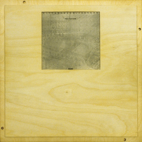
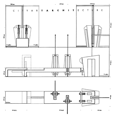
Wooden invitation box
Outside (top) and inside of the lid with inserted invitation (bottom).
Invitation and brief
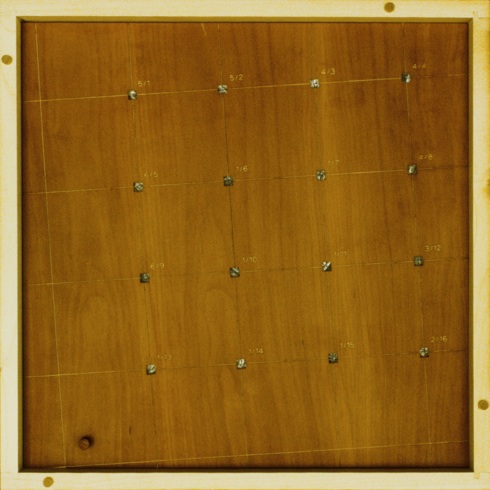
Content of the wooden box:
- Matrix of 16 sites on the crossing points of the UTM grid
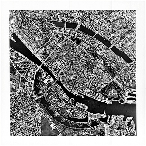
- Aerial Photograph of Copenhagen
- 8 Historical maps of Copenhagen
- 16 Sites (100 x 100 m.) on the crossing points of the UTM grid
Content of the wooden invitation box
Sub-lid with a matrix of square holes corresponding with the 16 crossing points of the UTM grid over the centre of Copenhagen
UTM grid
Transparent overlay
Aerial photograph
Historical map 1100
Historical map 1500
Historical map 1650
Historical map 1750
Historical map Roder
Historical map 1850
Historical map 1900
Historical map 1990
Site 5/1
Site 5/2
Site 4/3
Site 4/4
Site 6/5
Site 1/6
Site 1/7
Site 4/8
Site 6/9
Site 1/10
Site 1/11
Site 3/12
Site 1/13
Site 1/14
Site 1/15
Site 2/16
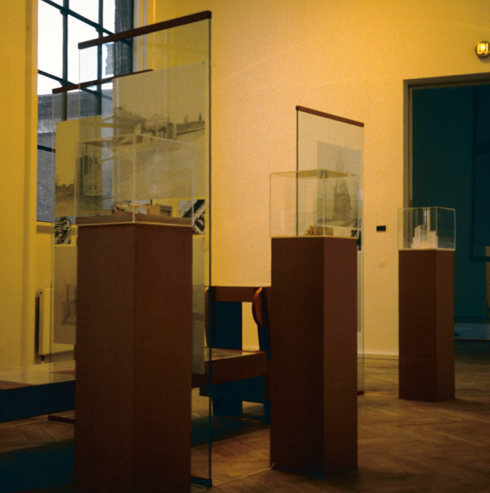
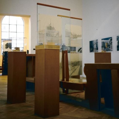
Exhibition
Exhibition